Saturday, 27 April 2024
Limits of Tanjung Manis Port
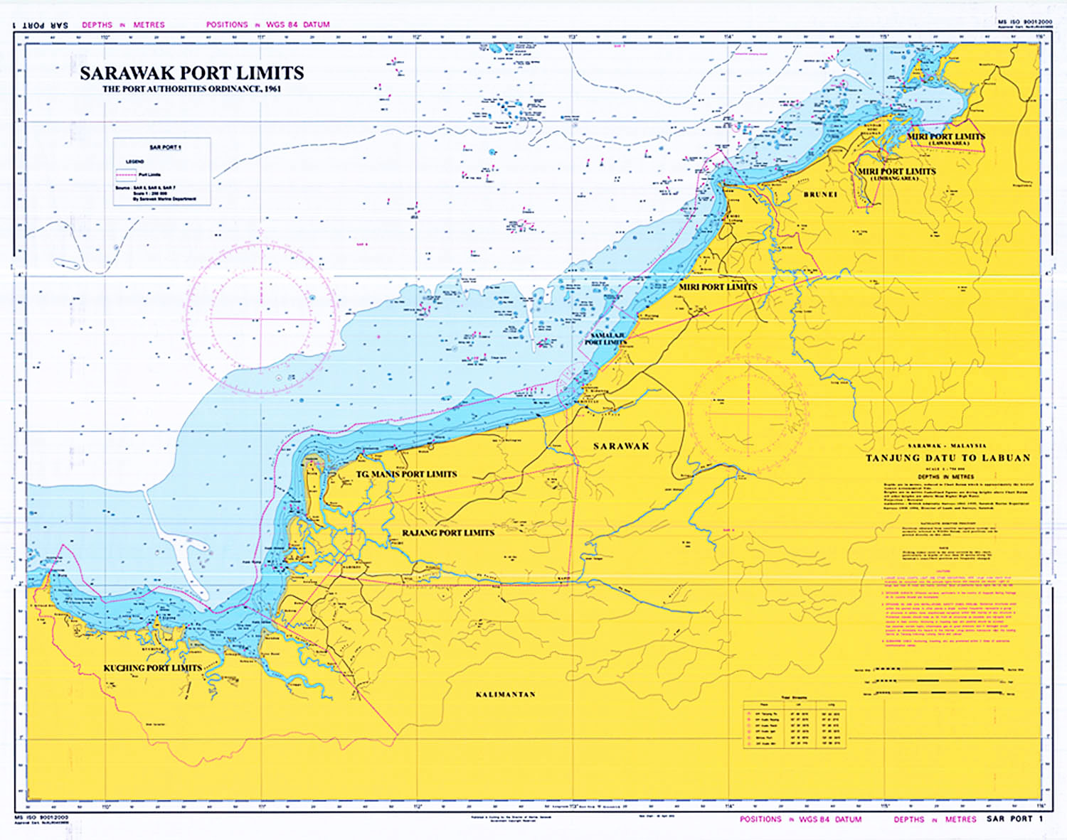
All navigable waters and all navigable rivers, streams, canals, and creeks up to the High Water Marks and all land from the High Water Mark to the land boundary within the following limits:
Outer Limits
| Description | |
|---|---|
(a) |
Commencing from a point at Tg. Sirik at latitude 02° 48' 28”.170 North, longitude 111° 20' 13”.562 East ; |
(b) |
thence in a southeasterly direction to a point north of Pulau Patok at latitude 02° 46' 04”.352 North, longitude 111° 24' 11”.693 East ; |
(c) |
thence crossing Muara Lassa to a point at latitude 02° 44' 59”.769 North, longitude 111° 30' 06”.419 East ; |
(d) |
thence along the Coastal High Water Line in northeasterly direction to Tg. Budu at latitude 02° 51' 00”.428 North, longitude 111° 38' 56”.531 East ; |
(e) |
thence crossing Kuala Igan to Tg. Duga at latitude 02° 50' 12”.988 North, longitude 111° 40' 33”.117 East ; |
(f) |
thence along the Coastal High Water Line in northeasterly direction to meet the limit of Bintulu Port at latitude 03° 08' 23”.720 North, longitude 112° 57' 52”.467 East ; |
(g) |
thence following the limit of Bintulu Port in semi circle to a point at latitude 03° 19' 44”.523 North, longitude 112° 54' 35”.836 East ; |
(h) |
thence an imaginary line parallel to the coastal line, maintaining at all places alongside the coast a distance of twelve nautical miles in southeasterly direction to a point at latitude 01° 52' 29”.531 North, longitude 110° 53' 14”.076 East ; |
(i) |
thence in a southeasterly direction to Tg. Batang Marou at latitude 01° 45' 58”.047 North, longitude 111° 04' 47”.965 East ; |
(j) |
thence in a northerly direction along the Coastal High Water Line crossing Kuala Kabong and Kuala Nyabor to Tg. Selalang at latitude 02° 05' 46”.092 North, longitude 111° 12' 32”.369 East ; |
(k) |
thence crossing Kuala Rajang to Tg. Jerijeh at latitude 02° 09' 07”.140 North, longitude 111° 09' 35”.994 East ; |
(l) |
thence along the Coastal High Water Line in northeasterly direction to Kampung Belawai at latitude 02° 14' 06”.090 North, longitude 111° 12' 45”.461 East ; |
(m) |
thence crossing Kuala Belawai to Tg. Manat at latitude 02° 14' 29”.697 North, longitude 111° 11' 25”.426 East ; |
(n) |
thence in a northerly direction along the Coastal High Water Line to Tg. Pasir at latitude 02° 26' 37”.240 North, longitude 111° 14' 25”.012 East ; |
(o) |
thence in a northerly direction along the Coastal High Water Line to Tg. Pasir at latitude 02° 26' 37”.240 North, longitude 111° 14' 25”.012 East ; |
(p) |
thence due north along the Coastal High Water Line on the east coast of Pulau Bruit back to Tg. Sirik at latitude 02° 48' 28”.170 North, longitude 111° 20' 13”.562 East, being the point of commencement. |
Inner Limit
| Description | |
|---|---|
(a) |
Commencing from a point at Tg. Sirik at latitude 02° 48' 28”.170 North, longitude 111° 20' 13”.562 East ; |
(b) |
thence in a southeasterly direction to a point north of Pulau Patok at latitude 02° 46' 04”.352 North, longitude 111° 24' 11”.693 East ; |
(c) |
thence crossing Muara Lassa to a point at latitude 02° 44' 59”.769 North, longitude 111° 30' 06”.419 East ; |
(d) |
thence along the Coastal High Water Line in northeasterly direction to Tg. Budu at latitude 02° 51' 00”.428 North, longitude 111° 38' 56”.531 East ; |
(e) |
thence crossing Kuala Igan to Tg. Duga at latitude 02° 50' 12”.988 North, longitude 111° 40' 33”.117 East ; |
(f) |
thence along the Coastal High Water Line in northeasterly direction to meet the limit of Bintulu Port at latitude 03° 08' 23”.720 North, longitude 112° 57' 52”.467 East ; |
(g) |
thence along the Coastal High Water Line in northeasterly direction to meet the limit of Bintulu Port at latitude 03° 08' 23”.720 North, longitude 112° 57' 52”.467 East ; |
(h) |
thence in a southeasterly direction to a point east of Batang Tatau at latitude 02° 47' 27”.315 North, longitude 113° 02' 13”.818 East ; |
(i) |
thence in a southeasterly direction to Tg. Gir at latitude 02° 28' 29”.791 North, longitude 111° 35' 21”.621 East ; |
(j) |
thence in a southeasterly direction to Loba Semah at latitude 02° 15' 50”.955 North, longitude 111° 34' 53”.707 East ; |
(k) |
thence in a southeasterly direction to a point southwest of Sarikei at latitude 02° 03' 53”.511 North, longitude 111° 25' 44”.821 East ; |
(l) |
thence in a southeasterly direction to a point south of Batang Kerian at latitude 01° 43' 31”.390 North, longitude 111° 09' 27”.842 East ; |
(m) |
thence in a northwesterly direction to Tg. Batang Marou at latitude 01° 45' 58”.047 North, longitude 111° 04' 47”.965 East ; |
(n) |
thence in a northerly direction along the Coastal High Water Line crossing Kuala Kabong and Kuala Nyabor to Tg. Selalang at latitude 02° 05' 46”.092 North, longitude 111° 12' 32”.369 East ; |
(o) |
thence crossing Kuala Rajang to Tg. Jerijeh at latitude 02° 09' 07”.140 North, longitude 111° 09' 35”.994 East ; |
(p) |
thence along the Coastal High Water Line in northeasterly direction to Kampung Belawai at latitude 02° 14' 06”.090 North, longitude 111° 12' 45”.461 East ; |
(q) |
thence crossing Kuala Belawai to Tg. Manat at latitude 02° 14' 29”.697 North, longitude 111° 11' 25”.426 East ; |
(r) |
thence in a northerly direction along the Coastal High Water Line to Tg. Pasir at latitude 02° 26' 37”.240 North, longitude 111° 14' 25”.012 East ; |
(s) |
thence due east and crossing Kuala Paloh to Tg. Sedi of Pulau Bruit at latitude 02° 26' 35”.004 North, longitude 111° 17' 37”.937 East ; |
(t) |
thence due north along the Coastal High Water Line on the east coast of Pulau Bruit back to Tg. Sirik at latitude 02° 48' 28”.170 North, longitude 111° 20' 13”.562 East, being the point of commencement. |
(The limits of the port is delineated in a map reference : SAR PORT 1 produced by Jabatan Laut Malaysia and deposited in the office of the Pengarah Laut Wilayah Sarawak. )